
A Special Council meeting on 8th June approved a draft new Local Plan which will be used as the blue-print for the development of the Borough up until 2039. The plan is now in a 12-week period of consultation which ends on Monday 13th September.
This is a controversial document as it proposes to build on Green Belt land, mainly in the north west part of the Borough. The full plan can be downloaded from the Council web-site. Health Warning: its a big document (15MB and 413 pages) and the download is very slow.
Contained in the plan are proposals to develop, or re-develop, many brown-field sites including supermarkets and low-rise retail areas. Tall buildings (defined by the Mayor of London as over 21m (7 floors)) are also envisaged throughout the Borough and the Plan shows the proposed maximum heights in different locations (Figure 7.4).
Some of the more controversial proposals include:
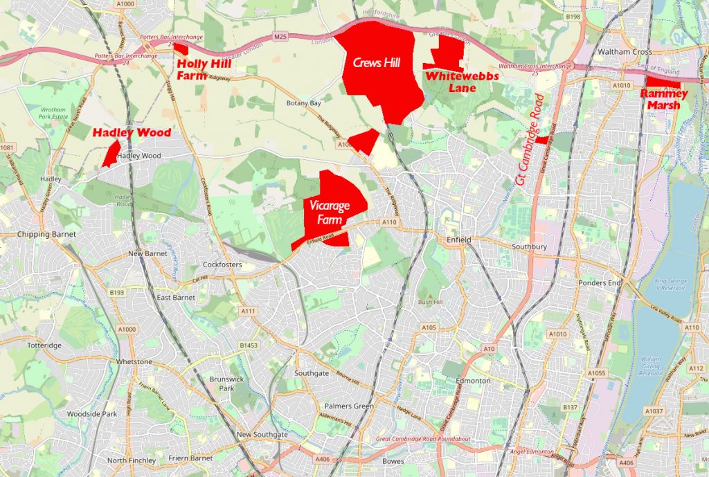
- building up to 3,000 homes at Crews Hill. The land for this will include the golf course and Green Belt farm land between the nurseries and the M25
- building a new housing estate (dubbed Chase Park) on land north and south of Enfield Road / Slades Hill (Vicarage Farm). Campaigning groups have already seen very detailed proposals by Comer Homes for this where a substantially higher number of houses is proposed (5,000)
- large expansion of land for Spurs to the north of Whitewebbs Lane
- the re-development of a number of local supermarkets including Sainsbury’s Winchmore Hill, Morrisons A10, Sainsbury’s A10 and Tesco’s Ponders End
- ‘conversion’ of the recreation fields at Firs Farm and to the east of the A10 (south of Church Street) for crematorium use
- permitted tall building in many locations of the Borough including at Enfield Town station (up to 51m, 17 storeys)
There are more details about some of these proposals on the Enfield Society’s web-site.
How to respond
The Council has provided three ways to respond: by email to localplan@enfield.gov.uk, by post, or via a web survey form at the separate ‘Let’s Talk’ webpage. This latter involves a ‘bespoke consultation platform’ but in reality it just hosts a survey that includes the same 72 questions as in the draft Local Plan document itself (albeit with different numbers). This is unnecessarily complicated and responses do not need to complete the survey.
The easiest way to respond to the consultation is to email localplan@enfield.gov.uk with the words ‘draft Local Plan’ in the title. If you wish to object to a particular part of the Plan, it is important that you state which specific part of the Plan you object to and why. You should cite the relevant paragraph, page, and figure numbers, and where possible the policy references. To help you we have included the references in the bullet point list above.
It is also important that you include your name and full postal address in any response. LBE has in the past dis-regarded respondents who have failed to provide this.